The San Juan Islands are an archipelago in the northwest corner of the contiguous United States between the US mainland and Vancouver Island, British Columbia, Canada. The San Juan Islands are part of the U.S. state of Washington.

In the archipelago, six islands are accessible by passenger ferry operated by the Washington State Ferries system.
The United States Geological Survey (USGS) defines the San Juan Islands as the archipelago north of the Strait of Juan de Fuca, west of Rosario Strait, east of Haro Strait, and south of Boundary Pass.[1] To the north lie the open waters of the Strait of Georgia. The USGS definition coincides with San Juan County. Islands not in San Juan County are not part of the San Juan Islands, according to the USGS.
History
Archaeologists use the term "Gulf of Georgia Culture Area" to refer to the San Juan and Gulf Islands, the whole of which shows many archaeological commonalities.[2] The San Juan Islands were part of the traditional area of various peoples of the Coast Salish ethnolinguistic group. Linguistically, Coast Salish groups in the area consist of the Nooksack, Northern Straits (which includes the Lummi, Klallam, Saanich, and Songhees dialects. Exploration and settlement by Europeans brought smallpox to the area by the 1770s. In 1843, the Hudson's Bay Company established Fort Camosun at nearby Vancouver Island.
The 1846 Oregon Treaty established the 49th parallel as the boundary between Canada and the U.S. west to the middle of the Strait of Georgia, and then by the main channel south to the Strait of Juan de Fuca and from there westwards to the open ocean. While both sides agreed that all of Vancouver Island would remain British, the treaty did not specify which channel the boundary should follow between the Strait of Georgia and the Strait of Juan de Fuca, resulting in a boundary dispute. This dispute, though simmering immediately in the wake of the treaty, escalated in the 1850s. In 1852 the Territory of Oregon created Island County, defined to include the San Juan Islands (or "Haro Archipelago"). In 1853 Island County became part of the newly created Washington 
Territory.[3] Washington Territory's legislature created Whatcom County out of parts of Island County, including the San Juan Islands. In 1855 Washington Territory levied a property tax on properties of the Hudson's Bay Company on San Juan Island, which the HBC refused to pay. Washington Territory then advertised and sold the properties to satisfy the unpaid taxes. This led to talks between the governors of Washington Territory and the Colony of Vancouver Island. It soon became clear that the US claimed Haro Strait as the international border, while Britain claimed Rosario Strait, with both sides laying claim to the San Juan Islands. The escalating dispute led to the Pig War in 1859 and the resulting San Juan Dispute, which was a protracted diplomatic confrontation. Effectively a stalemate, with no clear legal arguments, it continued until the boundary issue was eventually placed in the hands of Kaiser Wilhelm I of Germany for arbitration in 1871. The border, through Haro Strait, was finally established in 1872.
The name "San Juan" was given to the islands by the Spanish explorer Francisco de Eliza, who charted the islands in 1791, naming them Isla y Archiepelago de San Juan. The expedition sailed under the authority of the Viceroy of Mexico, Juan Vicente de Güemes Padilla Horcasitas y Aguayo, 2nd Count of Revillagigedo and Eliza named several places for him, including the San Juan Islands and Orcas Island (short for "Horcasitas"). San Juan Island itself was first discovered (by a European) by one of the officers under Eliza's command, Gonzalo López de Haro (for whom Haro Strait is named). The Spanish had found the islands a year earlier during the exploring voyage of Manuel Quimper on the Princesa Real, but it was not clear that they were islands.
Subsequent explorations of the region by the British, under George Vancouver, and the Americans, under Charles Wilkes, resulted in many of the Spanish names being replaced with English ones.
Vancouver's expedition occurred within a year of Eliza's, and Vancouver encountered other Spanish ships and traded information. Thus Vancouver knew of the names given by Eliza's expedition and tended to keep them, although he renamed some things, like the Strait of Georgia. Wilkes, sailing in 1841, had some British charts, but may not have been aware of the Spanish names and charts. He liberally gave new names to nearly every coastal feature not already named on the charts he had. The names Wilkes gave tended to be patriotically American (heroes of the War of 1812 for example), or to honor members of his crew.
In 1847, due to the confusion of multiple names on different charts, the British Admiralty reorganized the official charts of the region. The project, led by Henry Kellett, applied only to British territory, which at the time included the San Juan Islands but not Puget Sound. Kellett systematically kept the British and Spanish names and removed nearly all of Wilkes' names. In some cases Kellett moved Spanish names around to replace names given by Wilkes. Thus in Puget Sound itself, the names given by Wilkes are common and Spanish names rare, while the reverse is true for the San Juan and Gulf Islands (although the Spanish did not explore Puget Sound as thoroughly as the British and Americans, resulting in fewer Spanish names to start with).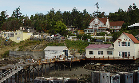
Wilkes had given the name Navy Archipelago to the San Juan Islands, and named individual islands for distinguished officers of the US Navy, such as Rodgers Island for San Juan Island, and Hull Island for Orcas Island. Some of his names survived the editing of Kellett, such as Chauncey, Shaw, Decatur, Jones, Blakely, Perry, Sinclair, Lawrence, Gordon, and Percival, all named after American naval officers.
The combined bodies of water including Puget Sound, the Straits of Georgia and Juan de Fuca, were recognized collectively as the Salish Sea, by the United States in 2009 and by Canada in 2010.

San Juan Islands today
Today, the San Juan Islands are an important tourist destination, with sea kayaking and orca whale-watching by boat or air tours, two of the primary attractions.
Politically, the San Juan Islands comprise, by definition, San Juan County, Washington.
There are 172 islands in the archipelago, some little more than rocks, and over 300 miles (480 km) of shoreline.[18] The majority of the San Juan Islands are quite hilly with some flat areas and valleys, often quite fertile, in between. The tallest peak is Mount Constitution, on Orcas Island, at almost exactly a half-mile (800 m) elevation. The coastlines are a mix of sandy and rocky beaches, shallow and deep harbors, placid and reef-studded bays. Gnarled, ochre-colored madrona trees (Arbutus) grace much of the shorelines while evergreen fir and pine forests cover large inland areas.
The San Juan Islands get less rainfall than Seattle, about 65 miles (105 km) to the south, due to their location in the rain shadow of Olympic Mountains to the southwest. Summertime high temperatures are around 70 °F (21 °C) while average wintertime lows are in the high thirties and low forties. Snow is infrequent in winter except for the higher elevations, but the islands are subject to high winds at times—those from the northeast sometimes bring brief periods of freezing and Arctic-like windchills.
No comments:
Post a Comment