The Ellora Caves are an impressive complex of Buddhist, Hindu and Jain cave temples built between the 6th and 10th centuries AD near the ancient Indian village of Ellora. The caves have a slightly less dramatic setting than those at Ajanta, but more exquisite sculptures. Ellora is a World Heritage Site and the most visited ancient monument in Maharashtra State.
 History
The caves at Ellora were carved out of the vertical face of the Charanandri hills between the 6th and 10th centuries. The carving work began around 550 AD, about the same time the Ajanta Caves (100km northeast) were abandoned.
The Ellora Caves were built at time when Buddhism was declining in India and Hinduism was beginning to reassert itself. The Brahmanical movement was especially powerful under the patronage of the Chalukya and Rashtrakuta kings, who oversaw most of the work at Ellora - including the magnificent Kailasa Temple built in the 700s.
The last period of building activity took place in the 10th century, when the local rulers switched allegiance from Shaivism (Hinduism devoted to Shiva) to the Digambara sect of Jainism.
The coexistence of structures from three different religions serve as a splendid visual representation of the prevalent religious tolerance of India. For this reason and others, the Ellora Caves were designated a UNESCO World Heritage Site in 1983.
What to See
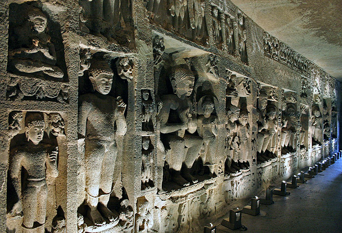
There are 34 caves in all: 12 Buddhist caves (500-750 AD), 17 Hindu caves (600-870 AD) and 5 Jain caves (800-1000 AD). The caves are numbered roughly chronologically, starting with the oldest Buddhist caves at the south end.
The Buddhist Caves
The Buddhist caves (also called Vishvakarma caves) are the earliest of the Ellora Caves, dating from 500 to 750 AD. All except Cave 10 are viharas (monasteries), which were used for study, meditation, communal rituals, eating and sleeping.
The caves become steadily larger and more elaborately decorated as they progress to the north, which scholars have explained by the growing need to compete with Hinduism for patronage. The earliest Hindu caves at Ellora date from 600 AD, right in the middle of the Buddhist period.
Cave 1 is a plain vihara with eight small monastic cells are very little sculpture. It may have served as a granary for the larger halls.
Cave 2 is much more impressive. A large central chamber supported by 12 great square pillars is lined with sculptures of seated Buddhas. The doorway into the sanctuary is flanked by a muscular Padmapani, holding a lotus, and a bejewelled Maitreya, the Future Buddha. Both are accompanied by their consorts. Inside the shrine is a stately seated Buddha on a lion throne.
Caves 3 and 4 have a similar design as Cave 2, but are in poor condition.
Cave 5 is named the Maharwada Cave because it was used by local Mahar tribespeople as a shelter during the monsoon. It centers on a grand assembly hall stretching 36 meters long, which was probably used as a refectory. The two rows of carved benches support this theory. The shrine Buddha is seated on a stool with his right hand touching the ground in the Earth Witness gesture.
Cave 6 was carved in the 600s and is home to two of the finest sculptures at Ellora. On the left is the goddess Tara, with an intense but kind expression. Opposite her on the right is Mahamayuri, the Buddhist goddess of learning, shown with her attribute, the peacock. A diligent student sits at his desk below. Significantly, Mahamayuri has a very similar Hindu counterpart, Saraswati.
The magnificent Cave 10 dates from the early 700s and is known as the Carpenter's Cave (Sutar Jhopadi) because of its imitation in stone of wooden beams on the ceiling. At the far end, a seated Buddha is enthroned in front of a large stone stupa.
Cave 11 is known as the Dho Tal or "Two Floors" cave, although a basement level discovered in 1876 brings the total floors to three. The top floor is a long assembly hall lined with columns. It has both a Buddha shrine and images of Durga and Ganesh, indicating the cave was converted into a Hindu temple after it was abandoned by the Buddhists.
Cave 12, known as Tin Tal ("Three Floors"), also has an impressive upper hall. The walls of the shrine room are lined with five large bodhisattvas and is flanked by seven Buddhas, representing each of his previous incarnations.
The Hindu Caves
Created during a time of prosperity and revival of Hindusim, the Hindu caves represent an entirely different style of creative vision and skill than the Buddhist caves. The Hindu temples were carved from top to bottom and required several generations of planning and coordination to take shape.
There are 17 Hindu caves in all (numbered 13 to 29), which were carved between 600 and 870 AD. They occupy the center of the cave complex, grouped around either side of the famous Kailasa Temple.
In contrast to the serene and solemn Buddhas of the earlier caves, the walls of the Hindu caves are covered in lively bas-reliefs depicting events from the Hindu scriptures. All of the caves are dedicated to the god Shiva, but there are also some images of Vishnu and his various incarnations.
Cave 14 dates from the early 600s and was converted from a Buddhist vihara. Its long walls are adorned with magnificently carved friezes and the entrance to the sanctuary is guarded by the river goddess Ganga and Yamuna. Inside, an alcove shelters seven large-breasted fertility goddesses (the Sapta Matrikas) holding chubby babies on their laps. Appearing to their right is the female aspect of Ganesh and the cadaverous goddesses of death, Kala and Kali.
Cave 15 is also a former Buddhist cave adopted by the Hindus. The ground floor is mostly uninteresting, but the top floor has some of the best sculpture at Ellora. Along the right wall are a sequence of panels showing five of Vishnu's ten incarnations or avatars, which give the cave its name, Das Avatara.
A panel to the right of the antechamber depicts the superiority of Shaivism in the region at the time - Shiva emerges from a linga while his rivals Brahma and Vishnu stand in humility and supplication. The cave's most elegant sculpture is in the left wall of the chamber: it shows Shiva as Nataraja, the Cosmic Dancer.
The most notable Hindu cave (Cave 16) is not a cave at all, but a magnificent temple carved from the solid rock, patterned closely on the freestanding temples of the time. It represents Mount Kailash, the abode of Lord Shiva, and is called the Kailashnath, Kailash, or Kailasa Temple. It originally had a thick coat of white plaster to make it look like a snowy mountain.
The Kailash Temple is a stupendous piece of architecture, with interesting spatial effects and varied sculpture. It is believed to have been started by the Rashtrakuta king Krishna I (756-773). The construction was a feat of human genius – it entailed removal of 250,000 tons of rock, took 100 years to complete and covers an area double the size of Parthenon in Athens.
Many more Hindu caves stretch down the hillside north of Kailash, but only three are must-sees: 21, 25 and 29.
Cave 21, the Ramesvara, dates from the late 500s and is thought to be the oldest Hindu cave at Ellora. It houses some fine sculpture, including a pair of rvier goddesses, two door guardians and some loving couples (mithunas) around the walls of the balcony.
Cave 25 features a sculpture of the sun god Surya driving his chariot towards the dawn.
North of this, the trail soon drops steeply down to a gorge, under a seasonal waterfall, and back up to Cave 29, the Dhumar Lena. Dating from the late 500s, it has an unusual cross-shaped plan. Pairs of lions guard its three staircases. Inside, the walls are covered in large friezes. To the left of the entrance, Shiva slays the Andhaka demon, then defeats the many-armed Ravana's attempt to shake him and Parvati off the top of Mount Kailash. Don't miss the dwarf baring his bottom to taunt the demon! On the south side, Shiva teases Parvati by holding her arm back as she prepares to throw dice in a game.
The Jain Caves
The Jain caves, dating from the late 800s and 900s, are 2 km north down an asphalt road (rickshaws are available). They reflect the distinctiveness of Jain philosophy and tradition, including a strict sense of asceticism combined with elaborate decoration. They are not large compared to others, but contain exceptionally detailed artworks. Many of the Jain caves had rich paintings in the ceilings, fragments of which are still visible.
The most notable of the group is Cave 32, the Indra Sabha (Indra's Assembly Hall), a miniature of the Kailash Temple. The bottom level is plain but the upper floor has elaborate carvings, including a fine lotus flower on the ceiling. Two tirthankaras guard the entrance to the central shrine. On the right is the naked Gomatesvara, who is meditating deeply in the forest - so much so that vines have grown up his legs and animals, snakes and scorpions crawl around his feet.
Travel Resources
Multilingual tours are available at the site, which last between 1 and 4 hours and cost about Rs550 for groups of up to four. Most visitors to Ellora make the day trip from Aurangabad, but there are couple places to stay in Ellora:
The Hotel Kailas, Ellora (02437 245 443) - chalets opposite the caves and some dorm beds
Vijay's Rock Art Gallery and Restaurant (no phone) - down the road from the Kailas, very basic, run for "visiting artists, writers and thinkers"
Lemon Tree Hotel (Aurangabad) - New, clean and friendly. Currently rated #1 in Aurangabad by travelers on TripAdvisor.
Taj Residency Aurangabad - "This is the best hotel in town, catering to Aurangabad's high society crowd as well as to business and leisure travelers" (Frommer's). Currently rated #2 by travelers on TripAdvisor.
The Ambassador Ajanta - "Set amid lovely lawns with fountains and well-maintained flower beds, the Ambassador offers good facilities and a comfortable environment -- ideal for relaxing after a hectic day of cave exploration." (Frommer's) Currently rated #6 by travelers on TripAdvisor.
Quality Inn The Meadows - "Surrounded by 5.2 hectares (13 acres) of pleasant gardens, this small resort - built in 1996 - is great if you'd rather stay out of town." Ask for superior, not deluxe, especially G1. Has a petting zoo. (Frommer's) Gets mixed reviews on TripAdvisor.
MTDC Holiday Resort - "If you want ultra-cheap and functional and intend on eating out, then by all means endure a night or two." Government-run. (Frommer's)

 Nigeria the most populated black nation in the world is situated in the western part of africa,with various tribal communities but the major tribes are THE YORUBA ,HAUSA, AND THE IBO TRIBES.these major tribes contitute the major grouping of the minor tribes in this country.


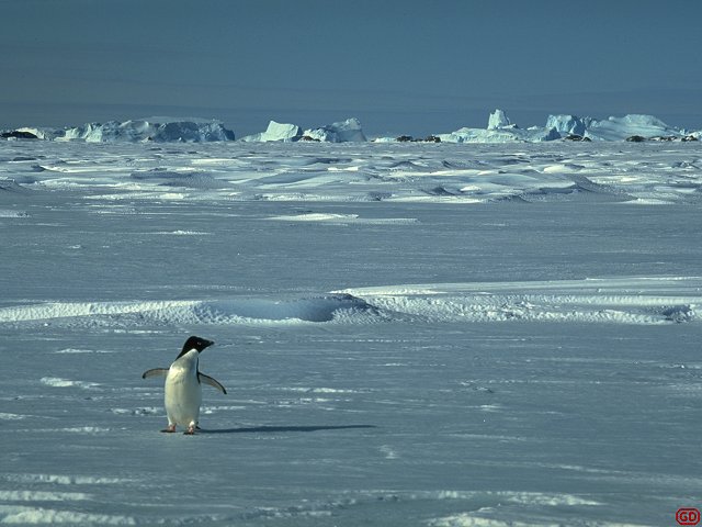 Most penguins spend the majority of their life at sea and return to land to reproduce. Getting to and from their reproductive areas (called rookeries) on land can be quite a walk but when there is snow to traverse, they often sled downhill to make quick descents.
 There are 17 species of penguins on Earth, six of which can be found in Antarctica - three brush-tailed, (genus Pygoscelis) - the Adelie, chinstrap, and gentoo; one crested (genus Eudyptes) - the macaroni; and two species of Aptenodytes - the king and emperor.
 Reproduction: Colonies may be of just a handful of breeding pairs or up to half a million birds and more. Many species lay two eggs, though it is rare that two chicks are raised, if food is short it will be fed to the biggest and strongest only. Male and female parents share egg and chick duty. Chicks are fed regurgitated fish and krill (yum!). The chicks leave the nest (or parents feet) when they are large enough to keep their own temperature constant, they form crèches to give each other mutual support and protection from marauding skuas and also to protect against the cold and wind.
 Unlike many historical sacred sites, the Golden Temple of Amritsar is still fully alive with religious fervor and sacredness, and visitors are welcomed to join in the experience. Although the building itself has great historical and architectural interest, it is the Golden Temple's great spiritual meaning for Sikh believers (and others) that is most memorable to visitors. In a country that is exceptionally rich with vibrant devotion, Frommer's rates the Golden Temple "the most tangibly spiritual place in the country."
 Kerala is a green strip of land, in the South West corner of Indian peninsula. Kerala is one among the longest-lived, healthiest, most gender-equitable, and most literate regions outside of the developed countries. "Though Kerala is mostly a land of paddy-covered plains, statistically Kerala stands out as the Mount Everest of social development; there's truly no place like it." says noted environmentalist Bill McKibben.

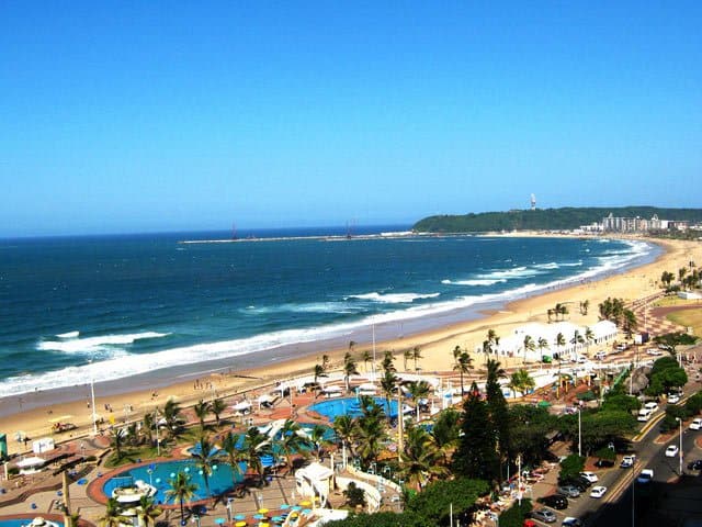 Durban is an exciting city in which to play, shop, experience the nightlife and to relax. It's a city in which business and debate issues, which have far-reaching effects, not only on Africa but way beyond its borders, are discussed.
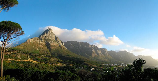
 Mountains crowd close to a shoreline dotted with beaches and bays, and vividly coloured wild flowers delight the eye. Between Heidelberg and Storms River, the Garden Route runs parallel to a coastline featuring lakes, mountains, tall indigenous forests, amber -coloured rivers and golden beaches. Meandering trails are followed by hikers, the forests invite long, leisurely drives, and the lakes and rivers lend themselves to swimming boating and fishing. A wide range of leisure options, spectacular scenery and a mild climate guarantee an unforgettable holiday experience when visiting the Garden Route in South Africa.
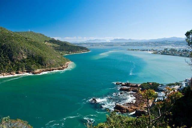
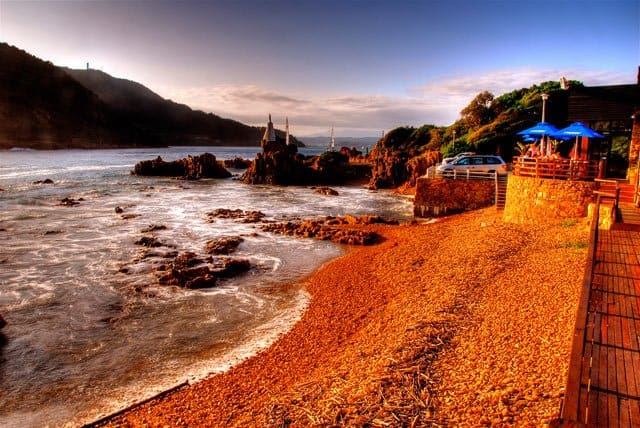 The 18 square kilometre Knysna lagoon is home to the unique Knysna seahorse, delicate pansy shell and at least 200 species of fish. The lagoon is actually an estuary, since the Knysna river meets the Indian Ocean here between two sandstone cliffs known as the Knysna Heads. On the Western Head is the Featherbed Nature Reserve, a World Heritage site. Here visitors can join a 2,5 km guided nature walk, the Bushbuck Trail.
 We can't leave southern Tuscany without visiting the Abbazia dei San Galgano, one of Italy's most stunning Gothic buildings, and the Abbazia di Monte Oliveto Maggiore, with its superb Renaissance frescoes. On to Montepulciano, at 600 metres above the sea it's the highest hill town in Tuscany. Then to Pienza, a Renaissance new town created from scratch by Pius II in 1459. Another lovely hill town nearby is Montalcino - wine buffs will know the name.
 Genoa, Italy's principal seaport, is easy to reach by public transportation. There's a small airport, ferries come into and out of its harbor, and its a main rail hub easily reached from France, Milan, Turin, Pisa, and Rome. The city makes a good base or starting point for exploring the first villages on our Italian Riviera travel itinerary.